November 21, 2017
Using GIS for Conservation Project Planning
By Legacy Land Trust Society
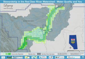
With the support of the Alberta Real Estate Foundation, Legacy Land Trust Society underwent its Water Quality & You project this year. This project focused on improving or maintaining the quality of the Red Deer River by engaging with landowners along the Red Deer River in Mountain View County to promote conservation and stewardship options. When Legacy started this project, they were faced with three critical questions. Who should they target? Where do they live? And how many are there?
“Without a visual representation of the landscape it is difficult to know how to devote resources to where they will do the most good.” said Tammy Mather the Executive Director of the land trust.
That is why Legacy worked to implement a Geographical Information System (GIS); an advanced software program that handles and visualizes spatial information like GPS data. Visualizing and layering data on a map can reveal relationships and patterns that may otherwise be missed from the ground. GIS is a powerful tool that can simulate and model real world events and scenarios, an invaluable resource for project planning.
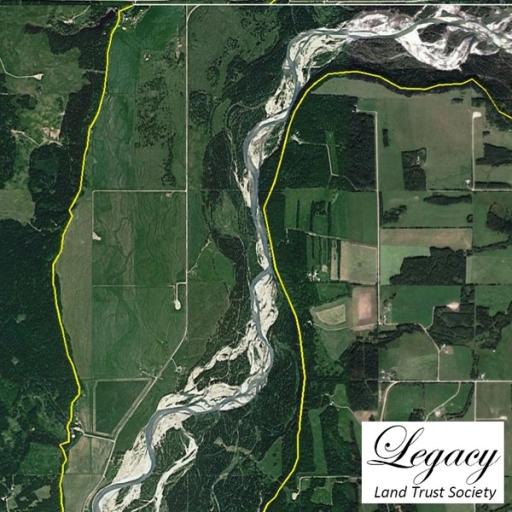
Red Deer River
Legacy was specifically interested in targeting the riparian area of the Red Deer River; an area along the river that provides an abundance of vegetation and wildlife habitat to the region. With a GIS and data sources in place, Legacy successfully modelled the riparian area of the river and identified land parcels within this boundary as parcels of interest to conservation. To further prioritize the efforts of the project the land parcels were ranked depending on the number of conservation features present. Finally, the results were migrated to an online map for additional members of the organization to access for preparation of outreach materials.
Using a GIS was a successful endeavor that dramatically informed Legacy’s planning process and helped prioritized their efforts. After completing the modelling of the riparian area and land parcel selection Legacy identified a potential 235 land owners to receive outreach materials along these 40 kilometers of the Red Deer River.
Interested in using GIS in your organization? Legacy received an ArcGIS license from ESRI Canada through their Non-Profit Organization Program. They offer grants of their software to non-profits whose focus is on environmental and humanitarian initiatives; qualified participants receive a full copy of ArcMap and community and self help support. Find out more here: ESRI Non-Profit Organization Program.
Legacy Land Trust would like to thank the Alberta Real Estate Foundation for supporting the Water Quality & You Project and ESRI Canada for providing the GIS platform. To learn more about Legacy Land Trust Society’s Water Quality and You project you can visit their page here: Water Quality & You
Topic
Similar News